
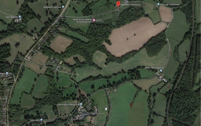
A local residents’ group has warned that a very large area – equivalent to 250 football pitches – between the A26 and Vauxhall Lane could be opened up to development if local people fail to object strongly enough to the Borough Council’s Local Plan.
The Hangman’s Hill Residents’ Association submission seen by Southborough News states that the plan for new housing on site AL/SO 3 is “unacceptably vague and unclear” as it covers the whole of the mile long strip of Green Belt land that currently separates Southborough and Tonbridge.

Serious concerns from Southborough Town Council about the plans were published on this blog on Sunday. The official deadline is 5pm today for comments to Tunbridge Wells Borough Council, which is the planning authority.
HHRA have an email to obtain a word document template for public submissions in the format required by Tunbridge Wells Borough Council. Send an email to:
hangmans@yahoo.com
The Hangman’s Hill Residents’ Association (HHRA) argues that the proposed allocation by Tunbridge Wells Borough Council (TWBC) of the site AL/SO 3 Land at Mabledon and Nightingale Farms is not adequate for a mixed-use scheme to include land-based economic development and approximately 50-120 residential dwellings.
HHRA told Southborough News its key objections were:
- the lack of clarity in the Draft Local Plan documentation set regarding the proposal – confusion as to where the site is and what exactly it will entail;
- the potential for inappropriate development in the Area of Outstanding Natural Beauty (AONB) and the Green Belt – as the site is in High Weald AONB, typically there need to be ‘exceptional’ circumstances to justify such ‘major development’, and in the view of HHRA no such ‘exceptional circumstances’ exist;
- the increased traffic congestion on the A26 – the additional traffic from this proposed development will exacerbate the existing congestion and air quality issues on the section of the A26 near the site and in the nearby area; and
- environmental and social impacts – including impact on ecology, biodiversity, and further strains on local amenities.
A committee member of HHRA said: “We have been blown away by the support from the community in relation to voicing their concerns against the prospective allocation of this site, and have been very grateful for everyone’s efforts to contribute to the campaign, and within a very short space of time”.
A Facebook page has been set up to post the latest news:
https://www.facebook.com/groups/hangmanshill/?epa=SEARCH_BOX
The Hangman’s Hill Residents’ Association argues that the Draft Local Plan just establishes that development in this protected landscape is acceptable to TWBC, and sets a dangerous precedent for the future.
Other detailed arguments made by the Hangman’s Hill Residents’ Association include:
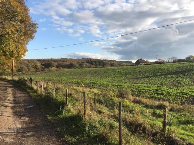
- This site is a glorious strip of green space between the built-up areas of Southborough and Tonbridge. There are views into the site from the A26, Vauxhall Lane, the Tunbridge Wells Circular Walk and public footpaths higher up the valley. Conversion of the small number of heritage farm buildings into homes has already taken place within the site.
- This is a very important area of biodiversity between the built-up areas of Southborough and Tonbridge. It includes a designated Local Wildlife Site (TW50 Vauxhall Lane Woods), which provides a vital habitat for a variety of species (e.g. great crested newts (protected species), rare dormice, deer, hedgehogs, badgers, foxes and owls). The gill woodlands and shaws provide important corridors, rich in biodiversity. There are traditional orchards, now a rare habitat, and rare early purple orchids.

- It’s an area of relatively Dark Skies, only 2 and 3 levels higher than the darkest skies (CPRE Light Pollution and Dark Skies interactive map), an essential haven for nocturnal wildlife.
- Away from the flood zones by the railway line, the topography and clay soil mean that the ground rapidly becomes waterlogged in periods of heavy rain due to run-off from the A26 and the network of underground streams and springs. This is not ideal land for development and will be made worse by additional impermeable surfaces.
